Solar and Battery Calculator for councils
For councils
Testimonials from subscribing Councils
“Hornsby Shire Council is pursuing both the purchase and generation of 100% renewable energy to actively meet our Net Zero by 2050 targets, which includes increasing the amount of solar on rooftops.
“During our community workshops, residents have told us they love using SunSPOT to discover what they might save if they install solar.
“SunSPOT is a great tool for helping figure out what size array is most effective on your roof."
Susie Smith, Sustainability Officer, Hornsby Shire Council, NSW
“SunSPoT is helping Council achieve its solar targets by providing a free, accessible and easy-to-understand DIY tool for residents to check their rooftop suitability and potential payback.
“Our staff also use SunSPOT during our Solar Conversations over-the-phone solar advice service for residents.
“We regularly receive feedback from our residents saying they love getting tailored information about their rooftop potential and that it helps give them the confidence to proceed with installing solar.”
Cad Currie, Sustainability Officer, Northern Beaches Council, NSW
Why councils should subscribe to APVI’s SunSPOT and the Solar Installation Dashboard
Not-for-profit solar research organisation the Australian PV Institute (APVI) is committed to helping Australian local councils reach their renewable energy goals. APVI has developed two unique online tools to do just this: SunSPOT Solar Potential Tool and the council Solar Installation Dashboards.
The standard version of SunSPOT is available to users all over Australia. The premium version of SunSPOT provides more accurate results and requires less inputs from the user. This is because it uses spatial mapping (LiDAR) data to read the shape, slope and orientation of the roof as well as year-round shading impacts from trees and other structures. Note that the premium version is only available for LGAs that have LiDAR data available.
In the image below, the red dots on the roof show the best position for solar panels on the roof. This is a feature of the premium version of SunSPOT.
Available together through a low-cost subscription, the premium version of SunSPOT and the Solar Installation Dashboards enable councils to:
Track solar uptake in the LGA
Estimate CO₂ emissions avoided through solar in the LGA
Estimate the savings, cost, system size and payback period of installing solar or a battery
Engage and inform their communities with tailored, unbiased advice about the benefits and opportunities of solar.
SunSPOT’s new accessible, user friendly re-design was made possible by support from the Australian Government, as was the development of the standard (LiDAR data-free) version that is available all over Australia,
for free.
SunSPOT allows councils, householders and small business owners to undertake a simple but reliable roof assessment in private and without having to talk to a solar sales company.
Before getting quotes, users can quickly and simply get key benchmark figures from SunSPOT to help them understand solar on their roof. They’ll learn what their suggested system size for the best return on investment is, and get an estimate of the cost, annual savings, and what size system they can fit on suitable parts of their roof.
They can find out potential savings from installing a battery.
SunSPOT is Australia’s only not-for-profit, free, reliable solar assessment tool built specifically to help rooftop owners.
SunSPOT moves people from ‘talking about solar’ (or batteries) to ‘investigating solar’, safely and privately.
Contact us to find out more about a subscription
Sign up to our monthly council newsletter
SunSPOT Blog
Track solar uptake and CO₂ avoided in the LGA with ease
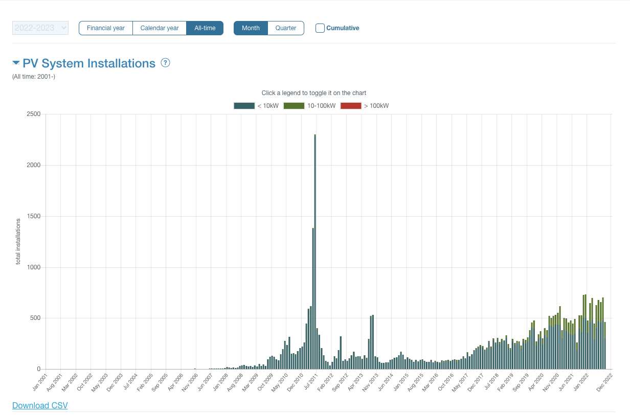
Over 50 councils in NSW and two in Victoria are enjoying the ease with which they can now track solar uptake month on month with APVI’s Solar Installation Dashboards.
The dashboards draw on data from the Clean Energy Regulator and APVI converts these into an LGA data set and provides analysis that allows councils to:
Track monthly increases in solar system numbers and capacity in the LGA
Compare household solar uptake % with surrounding councils
See average household annual savings from solar with a 7 kW system
See collective household savings from solar in the LGA
Track SunSPOT solar assessments in the LGA in real time
Have visibility of the localities (suburbs/towns) of all systems in the LGA broken down into domestic, commercial and large system sizes.
The data is updated every quarter and is downloadable.
See, for example, the ACT’s Solar Installation Dashboard
Have a look at the ACT’s Solar Installation Dashboard and scroll down to see all the tables. See also these screenshots showing some of the graphs and data in the tool.
Contact us to find out more about a subscription
Subscription pricing for councils
There are two types of subscription available to councils.
The Dashboard subscription provides access to a council’s Solar Installation Dashboard. A council might consider this if there isn’t suitable LiDAR data available for mapping their LGA. This subscription is $600+GST per year.
The Premium SunSPOT subscription is for the premium version of SunSPOT (with the incorporation of the LiDAR spatial mapping data) and the Solar Installation Dashboard for the LGA. The cost of this is based upon population size and priced to cover the costs of processing the data and mapping the LGA into SunSPOT. APVI is a not-for-profit organisation and our mission is to assist the uptake of solar. We make no profit from providing these tools to councils.
| Council population size | Annual subscription fee | Annual subscription with GST | Three year subscription with GST |
|---|---|---|---|
| Large: 50,000 + | $2,400 | $2,640 | $7,920 |
| Medium: Over 15,000 but less than 49,999 | $1,500 | $1,650 | $4,950 |
| Small: Less than 14,999 | $800 | $880 | $2,640 |
Contact us to find out more about a subscription
Download SunSPOT promo materials here
We’ll help you promote SunSPOT to your communities so they know they can get reliable, tailored, independent estimates about solar, batteries and savings with SunSPOT.
Users do not require a login, they simply access the tool via this website. If the address being searched is in an area that has not been mapped (no council subscription, or no LiDAR data) users will be using the standard version of SunSPOT.
If the address being searched is in an area that has been mapped into SunSPOT with LiDAR (usually where a council has subscribed), users will be presented with the Premium version of SunSPOT.
Regional councils that have a subscription funded by the NSW Government should use the materails for the Standard version as these are generic and will apply for your users who are in both mapped and non-mapped areas.
Our promotional kit includes:
text for your websites and newsletters
social media messaging
logos for print and online
screenshots from the tool
If your council is in a metropolitan area and has a subscription to the premium version of SunSPOT, download marketing and promotional content for your website and social media below.
If your ratepayers are using the free version of SunSPOT (available all over Australia without a council subscription), or the LGA includes rural and urban areas, you can download marketing and promotional content for your website and social media here.
Register here for a webinar
There are no Council-facing webinars scheduled at this point but Councils everywhere can promote our December 12, 2023 webinar for users. SunSPOT is available, free to use in all States and Territories.
7pm Dec 12, 2023
Register ›
Sign up to our council newsletter
Whether your council is using the free version or the premium version, you should sign up to our monthly newsletter with news about webinars about solar for your ratepayers, tool use tips, inspiration from other councils, and content for your community newsletters to help get more solar onto your LGA’s rooftops.
LiDAR data requirements to map your council into SunSPOT
In what format should the LiDAR data be supplied?
The premium version of SunSPOT (that councils are able to subscribe to) uses LiDAR data to detect the slope and orientation of a roof’s planes, as well as the impacts of shading from structures and vegetation. The estimates from this version are more accurate than from the standard version of SunSPOT.
The term LiDAR is an acronym for Light Detection and Ranging. LiDAR is a remote-sensing technique that uses laser light beams from a plane or drone to densely sample the surface of the earth, producing highly accurate x, y, z point measurements. A set of those points is called a point cloud.
To map a region in SunSPOT, we require point cloud LiDAR data with a minimum point density of 1.5 points/m2, although more than 5 points/m² is preferable as it allows for higher accuracy in the calculation of slope and orientation for a surface. Points classification is useful for helping us identify rooftops and remove noise, but not essential.
The data should be provided in .las or .laz format, and accompanied by the full metadata for the LiDAR data product which usually provides additional information like vertical and horizontal accuracy, date collected, whether it is classified or unclassified las etc.
We also require access to recent imagery for the area via a web server. For some states this data is publicly available and does not need to be provided by the council. If the imagery is not accessible and not able to be provided, we default to Google Maps imagery which is lower resolution, may be older than other imagery sources and may not have good alignment with the LiDAR data.
How much does reprocessing the LiDAR data cost?
If newer LiDAR data becomes available after the local government area has already been mapped, we can reprocess with the updated LiDAR data. If the council is able to supply the new data before any processing of earlier data has begun, it incurs no extra fee to incorporate it.
If the new data is supplied after the first steps of processing have begun, it will incur an additional fee of $900 + gst.
If your council provides a new LiDAR dataset after the LGA has already been mapped in SunSPOT, we need to re-do all steps of the process. This incurs a fee of $1750 + gst.
Compare solar uptake in every council in Australia
APVI develops high quality solar analysis tools including the Solar PV Status map. This map shows the estimated percentage of houses that have a solar PV system installed in every council in Australia. It also shows the total installed solar photovoltaic capacity in every council in Australia.
Find your council and compare!
Council Feedback Form
We'd love to hear your feedback to help us improve SunSPOT and the Solar Installation Dashboards.


SunSPOT is about to become an accredited service provider under the Consumer Data Right. This means your electricity data can been safely shared by your electricity network operator with SunSPOT.